Product Release Notes: 10/5/22
We are so excited to share the latest version of Anderson Optimization – easily our biggest update ever. Over the past two years, we’ve been working on a major backend transition to migrate our map tooling to a new platform called OpenLayers. OpenLayers gives our software development team a much sturdier and nimble base from which to deliver you awesome new mapping functionality.
This was a massive undertaking, and it required updates to nearly every part of the app. We have been vigorously testing away to make sure all use cases are accounted for, however, there may be some bugs or issues that slip through given the scope of the update. We will work to resolve any issues as quickly as we can, but please reach out if you notice anything not working as expected: support@andersonopt.com.
Many of the benefits of migrating to OpenLayers will already be felt today, but there are even more to come. Check out all the new features and updates in today’s release!
New Features
New ‘Energy Communities' layers
Project Management: Attach files to manage project documents and study files
Project Management: Manage details about user-uploaded KMZ layers
Landowner labels on saved parcels
Additional drawing icons
Point of Interconnection icon
Enhancements to existing functionality
Map performance
Revamped Layer Catalog
Consolidated ‘Map Tools’ menu
One ‘Select by polygon’ tool to rule them all
Constraint map setbacks now apply for hazards outside the site
Modified map pop-ups
Updated KMZ import
Edit parcel boundaries more easily
New Google Street View inset map
New Features
New ‘Energy Communities' layers (IRA)
Help stay on top of the new IRA law benefits through the new Energy Communities layers we rolled out. We have integrated three Energy Communities layers that are available to all users in the layers menu based on the sources cited in this Resources.org blog.

Project Management: Attach files to manage project documents and study files
Attach, manage, and share key files and study documents for a project campaign or specific site right in AO.
Attach project files and study documents (PDFs, Word docs, Excel/CSV spreadsheets, images, etc.) to a specific project or parcel via the new paperclip icon available on all project or asset detail pages.

Project Management: Manage details about user-uploaded KMZ layers
Manage key details about user-uploaded KMZ layers, including site study details and more. We’ll also be rolling out functionality soon to import Shapefiles and manage and edit details about those layers as well.

Landowner labels on saved parcels
OpenLayers enabled us to complete a long-requested feature to add landowner labels to saved parcels on the map so you can easily see who owns each parcel.

Additional drawing icons
Select from new icon options when adding a point on the map using the drawing tools.

Point of Interconnection icon
The new Point of Interconnection icon also gives you access to save details about the POI.

Enhancements to existing functionality
Map performance
One of the main reasons we moved to OpenLayers is for improved map performance. Maps should load more quickly and be less likely to lag even with larger datasets. There are still some additional performance improvements we can get here in the future as well.
Revamped Layer Catalog
We've begun a larger revamp of the layers menu now called the Layer Catalog. We will continue to update the Layer Catalog functionality in the future as well.
Layers are under this new layer icon on the map

Layer actions are located in the new ‘more details’ icon menu next to each layer name:

Layer source: Click the new ‘link’ icon to go to the source page (or hover over the icon to see the source name listed in the tooltip).

Active layers now visible in the Layer Catalog menu to help free up room on the map.
Click on the ‘Active Layers’ text to expand and see all activated layers on the map
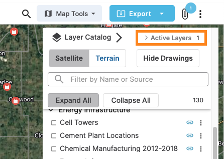

Easier to see pinned layers and favorited layers
Now able to collapse or expand all layers groupings with one click
Moved certain functionality from other locations to the new Layer Catalog:
Basemap selection (upper left)
Show/hide drawings on map (upper right)
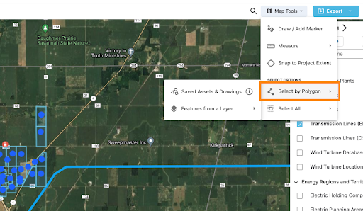
Consolidated 'Map Tools' menu
We’ve refreshed the map menu options and created a new Map Tools button and associated menu to make it easier to find all tools related to the map.

One ‘Select by polygon’ tool to rule them all
We were able to combine two legacy polygon selection tools into a single tool now available under the ‘Map Tools’ menu. You can now use this one tool to select and take action on saved assets OR to create assets from designated grid infrastructure layers (e.g. AO DG layers, 3rd party grid layers like Velocity Suite, Ventyx, Energy Acuity, and EIA/HIFLD).
Constraint map setbacks now apply for hazards outside the site
When you run the Buildable Area Analysis to create constraint maps, we now include setbacks for hazards outside the parcel/site boundary that impact the buildable acreage.
Modified map pop-ups
When you click on the map, if there are multiple objects where you clicked, then the pop-up will include tabs for each feature. This makes it easier to see information about any feature on the map, even if it's buried below other items. Click through the tabs to read more about any of the selected features.

Edit parcel boundaries more easily
If you need to edit a parcel’s boundary, it’s now much easier to adjust vertices.

New Google Street View inset map
When using Street View, there is now an inset map to make it easier to keep track of where you are on the ground.

We hope you enjoy this new release and please don't hesitate to reach out if you need help with any of the new features or if you have feedback -- you can reach us at support@andersonopt.com.